Annual Sea Dike Costs
Why is the content of this map important?
Sea-levels take many decades to respond to warming temperatures, so the effects of warming today will be felt a long time in the future. Coastal protection measures have long design lives, so future conditions need to be considered. These maps provide indicative costs of building sea dikes in the 2080s using the Shared Socioeconomic Pathway 2 (see Coastal Overview).
Which sectors are affected by this result?
These costs are helpful for coastal managers, either at European or national levels who require the estimated costs of protection to strategically and financially plan for the future. Specific sectors such planning could encompass include: infrastructure, transport and local communities.
What is shown on the maps?
These maps illustrate the annual sea dike costs in 2°C and 3°C worlds (assuming a median level of ice melt) in the 2080s in EU countries, with a 0.31m and 0.42m rise in global mean sea-levels respectively (data projections from the HadGEM2-ES climate model). The 3°C world is shown in the special map. The low-lying nations surrounding the North Sea have the greatest costs. Europe's smallest economies benefit most from climate change mitigation, as shown in the difference in costs between the two maps.
Details and further information:
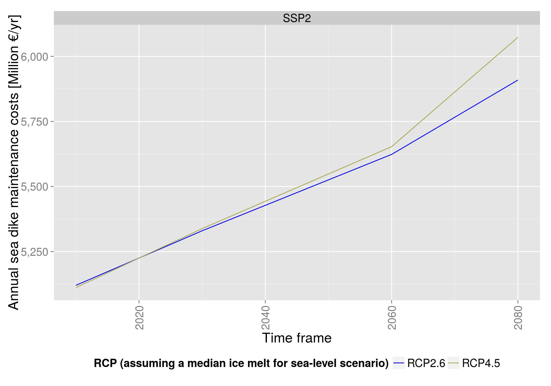
Sea dikes must also be maintained in order to remain effective. Projecting maintenance costs at 1% of capital dike costs indicates that in a 2°C world in the 2080s, annual maintenance costs are projected to be € 5.9 billion per year. In a 3°C world, these maintenance costs could increase up to € 6.1 billion per year.
Alternative adaptation measures, such as sand nourishment, managed realignment or elevating houses can also reduce flood risk.
Sea-level scenarios were extracted from:<o:p></o:p>
Hinkel, J., Lincke, D., Vafeidis, A.T. Perrette, M., Nicholls, R.J., Tol, R.S.J., Marezion, B., Fettweis, X., Ionescu, C. & Levermann, A., 2014. Impact of future sea-level rise on global risk of coastal floods. doi: 10.1073/pnas.1222469111<o:p></o:p>
The costs were generated from the Dynamic Interactive Vulnerability Assessment (DIVA) modelling framework. Further information about DIVA may be found at www.diva-model.net and the following references:<o:p></o:p>
Hinkel, J., 2005. DIVA: an iterative method for building modular integrated models. Advances in Geosciences, 4, 45-50.<o:p></o:p>
Hinkel, J. & Klein, R.J.T., 2009. Integrating knowledge to assess coastal vulnerability to sea-level rise: The development of the DIVA tool. Global Environmental Change 19(3): 384–395.<o:p></o:p>
Vafeidis, A.T., Nicholls, R.J., McFadden, L., Tol, R.S.J., Hinkel, J., Spencer, T., Grashoff, P.S., Boot, G. & Klein, R.J.T., 2008. A new global coastal database for impact and vulnerability analysis to sea-level rise. Journal of Coastal Research, 24, 917-924.<o:p></o:p>
Hinkel, J., Nicholls, R.J., Tol, R.S.J., Wang, Z.B., Hamilton, J.M., Boot, G., Vafeidis, A.T., McFadden, L., Ganopolski, A. & Klein, R.J., 2013. A Global Analysis of Coastal Erosion of Beaches due to Sea-level Rise: An Application of DIVA. Global and Planetary Change 111, 150–158.<o:p></o:p>
Author:
Sally Brown
University of Southampton (SOTON), United KingdomRobert J Nicholls
University of Southampton (SOTON), United KingdomDaniel Lincke, Jochen Hinkel
Global Climate Forum, Germany
